

The wild weather we’re seeing is caused by a phenomenon called the “Black Nor’easter”.
Meteorologists have used this name since the 1800s to describe the dark, moisture-laden clouds that travel in from the north-east and can turn the middle of the day dark.
It occurs when a cool pool of air (coming from across the Great Australian Bight, for example) converges with a moisture-rich coastal trough supercharged by warmer ocean temperatures.
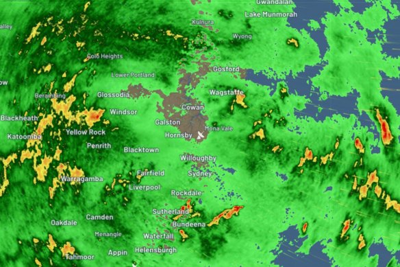
The radar over Sydney, as of 5am AEDT this morning. Credit: Weatherzone
The convergence of the two weather systems is a recipe for wild weather as warmer ocean temperatures this time of year cause more evaporation, increasing the amount of water in the atmosphere.
When this moisture is carried south by humid north-easterly winds and cooled by the colder air in the upper-level low-pressure system above, it condenses and falls as rain.
Weatherzone meteorologist Yoska Hernandez told me yesterday the phenomenon would bring very dark skies and anywhere from 100 to 300 millimetres of rain to Sydney between Thursday and Saturday afternoon.
“The amount of moisture in the atmosphere is going to be very elevated, so the clouds are going to look black because of the amount of moisture available,” she said. “Most of the rain is going to fall on Friday and into Saturday morning.”
Those humid northeasterly winds would also bring gusts up to 80km/h along the NSW coast from late afternoon on Friday to Saturday morning, Hernandez said.
Sydney and the rest of the state is bracing for gale force winds and possibly deadly flooding as the trough causing wild weather on Australia’s east coast is expected to deepen.
The Bureau of Meteorology updated their severe weather warning this morning to warn residents across Sydney, the Illawarra and the Central Tablelands to expect heavy rainfall leading to possible flash flooding.
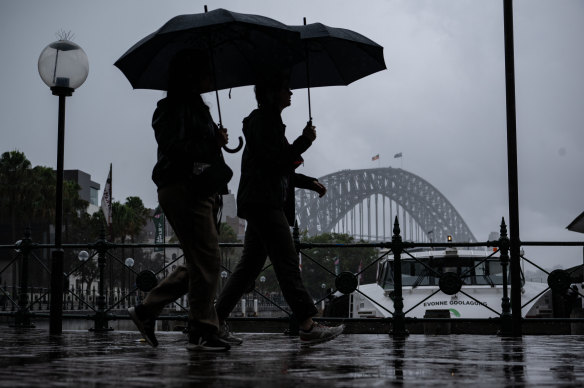
Wet weather at Circular Quay.Credit: Wolter Peeters
The warnings are particularly dire between the Blue Mountains and Narooma where the Bureau is expecting intense rainfall may lead to “dangerous and life-threatening flash flooding” from this evening into Saturday morning.
Between 90 and 150 millimetres is expected to fall in just six hours, reaching up to 220 millimetres on the Illawarra escarpment – which could record up to 300 millimetres in the next 24 hours.
Speaking to my colleague Christopher Harris last night, a bureau spokesman said the heavier rainfall was set to start later today.
“The most intense rainfall is from Friday evening into Saturday morning… There could be a few thunderstorms with it,” he said.
However, he said, it was tricky to predict precisely which areas would be worst affected.
“From the point of view of the quantity of rainfall and timeframe in a certain area, is difficult to predict.”
The weather bureau has also issued flood warnings for catchments across the state, for the following areas:
NSW flood watch warnings:
- Tweed and Rous Rivers (minor flooding)
- Richmond River (minor flooding)
- Orara River (minor flooding)
- Coffs Coast
- Bellinger and Kalang Rivers (minor flooding)
- Nambucca River (minor flooding)
- Hastings River (minor flooding)
- Camden Haven River (minor flooding)
- Manning and Gloucester Rivers (minor flooding)
- Wallis Lake (minor flooding)
- Myall River (minor flooding)
- Karuah River
- Goulburn and Upper Hunter Rivers (minor flooding)
- Wollombi Brook and Lower Hunter River (minor to moderate flooding)
- Newcastle Area
- Paterson and Williams Rivers (minor flooding)
- Central Coast
- Lake Macquarie (minor flooding)
- Upper Nepean River (minor to major flooding)
- Hawkesbury and Lower Nepean Rivers (minor to major flooding)
- Upper Coxs River
- Colo River (moderate to major flooding)
- Macdonald River
- Northern Sydney
- Southern Sydney
- Parramatta River
- Cooks River (minor flooding)
- Georges and Woronora Rivers (minor to moderate flooding)
- Illawarra Coast
- Shoalhaven Riverminor flooding
- St Georges Basinminor flooding
- Clyde River
- Moruya and Deua Riversminor flooding
- Tuross River
- Bega Riverminor flooding
- Towamba River
- Upper Macintyre Riverminor flooding
- Gwydir Riverminor flooding
- Macquarie River to Bathurst (minor to moderate flooding)
- Orange, Molong and Bell River (minor to moderate flooding)
- Lachlan River to Cotton’s Weir (minor flooding)
- Belubula River (minor to moderate flooding)
- Mandagery Creek (minor flooding)
- Queanbeyan and Molonglo Rivers (minor flooding)
Good morning and welcome to our rolling coverage of the wild weather hitting Sydney and much of Australia’s east coast.
My name is Angus Thomson and I’ll be with you until the early afternoon.
It’s bucketing down here in Sydney and the state has had a lot of rain overnight. Here are some of the big numbers recorded in the last 24 hours:
- In the Sydney basin, 100 millimetres of rain has fallen at Sydney’s Observatory Hill, Penrith recorded 73 millimetres, and Wahroonga has had 99 millimetres of rain since 9am AEDT yesterday.
- Near Lismore, Nashua (Wilsons River) had 219 millimetres, Houghlaghans Creek notched 138 millimetres, Coopers Creek had 142 millimetres and Tuckurimba had 141 millimetres
- Staying in the Northern Rivers, Mullumbimby has had 100 millimetres and the Morning View observatory at Green Pigeon near the Queensland border notched 111 millimetres.
We’ll keep these numbers updated throughout the day, with the worst of the rain and damaging winds expected to come later this morning.
Read More: World News | Entertainment News | Celeb News
SMH